
From manual drawings and evolving to technology like 3D imaging, the industry has come a long way in the last two decades.
While technology isn’t always a boon to every industry, for construction and excavation in particular, moving a long way from its roots of manual digging with shovels is indeed a positive.
The Industrial Revolution was the driving force behind the first attempts at using machines to automate the task of removing and grading soil. “The very first excavator to use hydraulic technology was built in 1882 by Sir W. G. Armstrong & Company in England, where it was used in construction of the Hull docks.” (Source)
Over the decades since, many attempts have been made to improve not only the equipment but the methods used in excavation projects.
How the excavation industry looked in the past
In the more recent past—twenty years or less—the technological advancements that have improved the industry have been growing exponentially.
In the past, manually produced drawing were used to examine the site and plan the excavation, including ensuring minimal impact to surrounding habitats, and the boundaries of the excavation, both in depth and surface size. Geotechnical investigations of the sites revealed less, resulting in unexpected issues with the site condition, such as buried debris, a higher than expected water table and so on.
In addition, the heavy equipment used before the early 1990s was cumbersome, to say nothing of not particularly environmentally friendly, putting out carbon emissions at astronomical rates. Growing demand for more compact and emission friendly machinery began an evolution towards higher efficiency in the overall projects. The key to developing that efficiency was technology.
Key changes that have improved project success
- Real time communication — using technology to link machines on the site and their operators to real time data displays allows all decision makers, regardless of where they are located, to view and interpret the machine data. This makes for better two way communication and faster decision making.
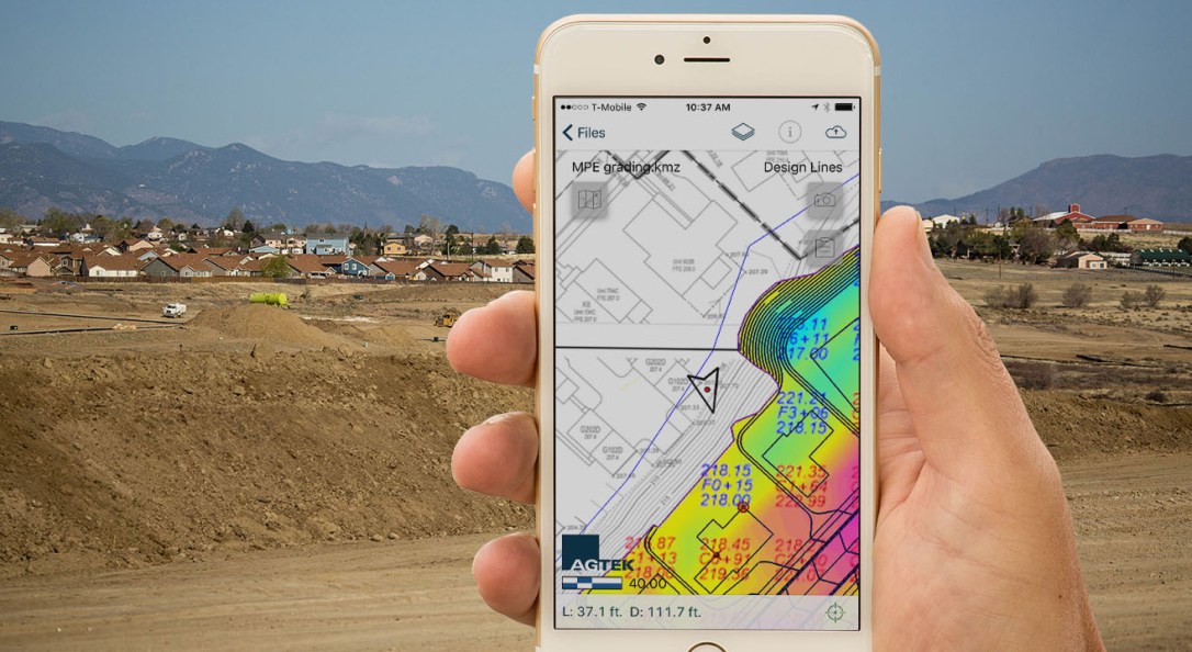
- Accurate imaging and site positioning — GPS, lasers and optics are all used to create accurate positioning and data relays that allow the human operators to effectively do their jobs, eliminating rework and allowing for effective estimating at the beginning of the project. Further, upgrading the 2D plans produced by the civil engineers to 3D models provides more useful data, particularly with regards to the subgrade model. Problem areas, such as poor drainage areas, can be spotted and addressed before moving the heavy equipment into place.
- Elimination of certain tasks through the use of technology — 3D designs and grade control systems allow for precise grading and earthmoving, skipping rough grade and cutting the site directly, to finish grade in a single activity. Further, machine metrics and automation reduce the need of manual measurement checks, which are both heavy in time and cost. These plans ensure bids are accurate and precise, so that the work can take place as projected, on time and budget.
- Reduction of risk / safety for workers — training in the various tools ensures that all the workers have access to the information they need to perform their jobs safely and accurately. From planning and training to documentation and processes, having access to the right information and tools allows each project to be conducted safely and with optimal staffing.
How the excavation industry looks today
With the power of technology comes the ability to serve customers more fully and accurately, with end to end project site development. From the initial site evaluation to estimate preparation, to determining the scope of work and to the actual effort of  earthmoving and excavation, achieving the goals of the project completion, on budget and on time.
At OE Construction, we are experienced in the use of Trimble® Grade Control Systems, providing the opportunity to better manage equipment, as well as to gain a better understanding of how each machine is operating in the field. The Trimble Connected Machine solution provides OE the chance to collect as-built measurement data quickly, to deliver such data to the office, and to receive GNSS corrections online almost instantly.
More precise grading and earthmoving are achieved due to the speed at which the office created 3D design is sent to the machine operator. By providing the office and machines in the field the latest information, and keeping each up to date throughout the course of each project, both rework and drive time are drastically reduced, even minimized, saving invaluable time and money while optimizing project efficiency.
