USING 3-D MODELING, GPS TECHNOLOGY AND HEAVY EQUIPMENT MACHINE CONTROL IN THE FIELD
By OE Construction Corp.
When OE builds larger construction sites (typically over 5 acres in size), we incorporate a number of tools and technology to move the dirt around and prepare the site for the next step in construction. The next step might be a building(s), installing a liner (for disposal and oil and gas locations) or preparing the site for future development.
First OE creates a 3 dimensional computer software model of the work from the construction plans (for the civil portion of the work). This includes the excavation, subgrade and finish grade model of the site and if required the building foundations, landscaping, walkways, drainage areas, parking areas and other site related items noted on the civil plans. This 3-D model includes “layers” created for each portion of the job and is specific to each machine used to build the site. Each machine “layer” of information is transferred to a memory stick, USB type storage device. These “layers” are what make up the “machine control” instructions for each piece of equipment to be used on the job. Typically the heavy equipment used are loaders, dozers, motograders, skid steers and in some cases excavators/trackhoes. The information is then transferred to each machine via the USB storage device (basically plugged into the on-board system/control box in each machine).
Before the process can begin in the field, i.e. actually building the site and moving the dirt, OE will establish a number of control points across the job site. In addition, we will add a GPS base station to the job site, which is needed to communicate information to the equipment and establish the correct GPS positioning of the machines during the construction process.
 Each machine has a visual display area that communicates what is happening outside the machine to the operator in the machine. The operator is able to view the progress real time, including what the on-board control system is moving on the machine. For example; the on-board control system will move the blade on a motograder, the bucket (including the angle) on a loader, the depth of earthwork cut (for all equipment), and so on.
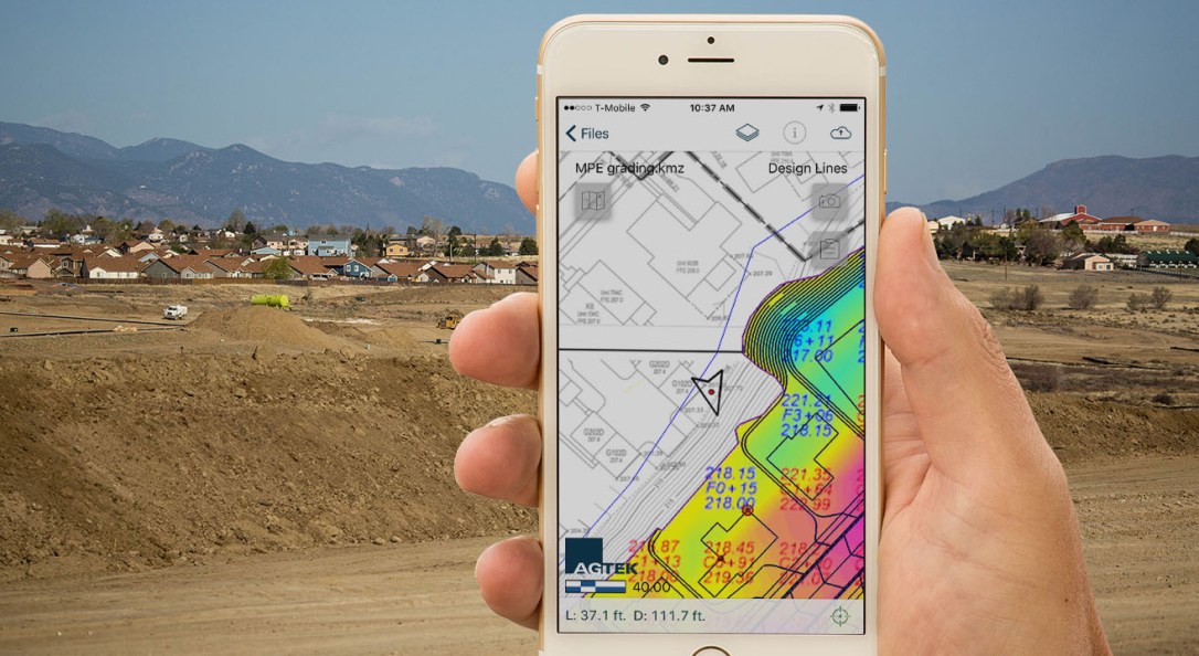
The grade checking is verified a number of ways, including using a special tablet with the job site data and a grade checking GPS enabled grade rod or you can also verify with the machine itself. Once the project is complete, OE will compile a master as-built of the site using all of the machine “layers” that were built during the project. In some cases, we can also resurvey the site with a drone and verify the results to the original plan, in about half a day. Wow, if we used the old fashioned way of surveying the site it might take a week to get the final verification. Using this technology can save the customer time, money and is thousands of times more accurate in achieving the final site layout.
If you want to see this technology in action, give us a shout – chris@oeconstruct.com (303) 526-0621.
OE Construction Corporation – USING CUTTING EDGE TECHNOLOGY TO SAVE OUR CUSTOMERS TIME AND MONEY AND DO THE JOB RIGHT THE FIRST TIME.
WWW.OECONSTRUCT.COM